Sources
H. S. Halbert
 Henry Sale Halbert (Halbert) 1837-1916 served the Choctaw in Mississippi 1884-1899. You will find his biography on Wikipedia. He was a Choctaw speaker, a teacher and a joint editor with John Swanton of A Dictionary of the Choctaw Language, Washington D.C., Cyrus Byington, Government Printing Office, 1915: BAE Bulletin 46. Halbert left Mississippi to work for Alabama Department of Archives and History. He authored books about the Creek wars including Choctaw participation. His surviving notes and papers including Choctaw materials are in Montgomery under care of Alabama Department of Archives and History, where you can find the grouping of his Papers. Regarding the Choctaw villages, Halbert was devoted to discovering their locations, Choctaw names and meanings. His best sources were the Choctaw. He asked them where their villages were sixty years or more before. If not for the traditional stories told and retold by the Choctaw elders, Halbert's Choctaw village world would be reduced.
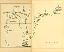 Halbert's first writing concerning the Choctaw villages was an article in Mississippi Historical Society (MHS), Volume 3, Oxford, 1901 page 367 entitled Danville's Map of East Mississippi. Halbert found d'Anville's (Jean-Baptiste Bourguignon d'Anville) map in Colonial Mobile: . . . , a book by Peter J. Hamilton. The map "The River Basin About 1732" is provided along with the book Colonial Mobile by the digital library of Internet Archive, a non-profit company. The 1732 French map presented less than a dozen Choctaw "CHATAS" villages (upper left) surrounded by their key waterways. Mobile Bay is situated in the lower center of map just left of page crease. In the MHS article Halbert, using Choctaw village names, creek names and general waterways' locations, suggested locations for four of the Choctaw villages. Halbert knew that there were more villages; he needed a map with more focus on the Choctaw villages.
Romans, Bernard (The Original Map)
A Map of West Florida Showing Choctaw Settlements (1772)
Bernard Romans, a Dutch-born navigator, surveyor, cartographer, engineer and naturalist, was engaged as a surveyor/cartographer by the British Indian Agent Southern District John Stuart in Pensacola. Romans started the survey of the Choctaw and Chickasaw villages and points of interest in August 1771 and finished in early 1772. The British had gained control of East and West Florida from the French in 1763 by treaty. The original map had the Choctaw villages in a numbered list of 1-60 within a legend on the map. The 1772 original map was used by Albert S. Gatschet (below) to produce the Gatschet Map, a facsimile of Romans' 1772 map. Romans also produced a 1773 map, (again look below) which appeared to have similar creek names and locations, village names, numbers and locations compared to the Gatschet copy. Unfortunately, the original 1772 map was lost, apparently while in Gatschet's care.
Romans, Bernard (The Gatschet Map)
A Map of West Florida Showing Choctaw Settlements (1772)
Obviously, Halbert's Choctaw villages' locations interest was piqued once he viewed Gatschet's facsimile of Bernard Romans' Map 1772 . Gatschet and Halbert corresponded. Gatschet was a linguist who worked for the Bureau of American Ethnology in Washington D.C. The map, courtesy of Research Laboratories of Archaeology The University of North Carolina at Chapel Hill, was copied by Dr. Albert S. Gatschet from Romans' A Map of West Florida 1772. Note the Chickasaw territory is located at the top of the image and Choctaw villages are in the middle and numbered.
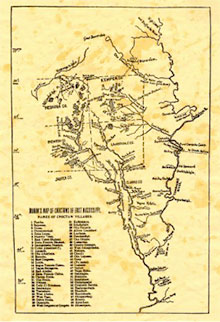 A second copy of Gatschet's facsimile noted on the map. is courtesy of the Mississippi Department of Archives and History. Significantly, a list of Choctaw village names and numbers has been added to the map. The listed village numbers have also been added to the map at their locations per Romans. Note Romans indicated and located 60 Choctaw villages on the 1772 map. By way of orientation the "Pearl River" bounded the villages on the upper left while the "Tombigbee River" protected the right. To the immediate south rests the Chickasawhay River and its tributaries. Given the original Romans' map scale and coverage, it is remarkable to have a semblance of accuracy representing the Choctaw villages and their environs. Romans divided the Choctaw Villages into three groups: "Ockoloo Hanale or Sixtowns", "Oocoloo Falaya or Western Party" and "Oypat Oocoloo Eastern Party."
Gatschet notably added the county lines of Newton, Lauderdale, Kemper and Neshoba which of course did not exist until years after the Treaty of Dancing Rabbit Creek or 1831.
Other features noted on the Gatschet Map included the names and locations of the creeks situated near the Choctaw villages. The Choctaw villages are shown as black banded irregular areas with their centers either hatched or vacant. These irregular areas probably indicate the ridges that the villages occupied. One may conclude the size of the areas is relative comparing one village to another. Paths are indicated as dashed or dotted lines. We suggest you take time to inspect the map. Halbert used it extensively. It is from the Gatschet facsimile of Romans' Map 1772 that Halbert's second MHS article was written, below.
Halbert's 1902 MHS Article:
Bernard Romans' Map of 1772
You can read Halbert' article "Bernard Romans' Map of 1772" here, courtesy of Mississippi Genealogical & Historical Society. Suggested article navigation is via the "Next" and "Back" buttons in the lower left of each page. If you become lost, as we did, click one of the blue villages (or blue creek names if you are really lost) names in the table. In the text Halbert's Choctaw village names and corresponding numbers which are in bold refer to Romans' (Gatshet) map names and numbers (e.g. 1. Panthe). Recall Halbert's paper excluded Choctaw villages' numbered 41-56 which were not located in Lauderdale, Neshoba, or Kemper counties. He stated that these villages were to follow in a companion paper (see A. J. Brown below). Having a split screen on your computer with Halbert's paper on one side and Gatschet's map on the other will certainly aid your experience. Also review the Choctaw names and locations of the creeks and waterways in Halbert's article.
Halbert's 1901 and 1902 papers proposed a number of specific village locations, including Township, Range and Section. He also noted several faults of Danville's and Romans' maps. Specifically, in his 1902 article,
"The maps made in the eighteenth century . . . are singularly inaccurate as to the water courses . . ."Further, he added that Romans' map was "confused as to Oktibbeha and Buckatunna creeks." As to the accuracy of Romans' map he noted,
"Romans is tolerably accurate in his location of what may be called the Kemper county towns (villages) . . . But he is not so accurate as to the location of the Neshoba county towns and settlements, and he is very confused and inaccurate as to those of Newton and Jasper counties."And for the "coup de grace" Halbert finished Romans with,
"His knowledge of the towns and settlements of Neshoba, Newton, and Jasper counties seems to have been based largely on Indian hearsay."Despite these shortcomings, Halbert provided specific Choctaw names of the villages and in many cases the Choctaw creek names which the villages were located. In addition, he provided the "anglicized" names of both where evident. As for the paths he noted where the eighteenth century paths had morphed in time to then existing roads or previously to military roads. In short, Halbert expanded the Choctaw universe that Romans and Gatschet contributed. You will soon discover earlier French Choctaw villages' sources. The eighteenth century Louisiana French officers would say that Halbert "struck a blow" for Choctaw history and posterity. Soon, you will meet several of these officers.
Brown's 1902 MHS Article:
Antiquities of Newton County, Mississippi
Halbert enlisted Captain A. J. Brown of Newton County to locate Romans' villages numbered 41-47. A. J. Brown's Antiquities of Newton County, Mississippi was published as a companion to Halbert's Bernard Romans' Map of 1772 in MHS Volume 6, Oxford, 1902. The article attempted to locate Romans' villages numbered 41-47, or villages (thought then to be) located in Newton County.
A. J. Brown's 1902 reprinted MHS paper courtesy of Newton County, Mississippi Historical and Genealogical Society. Note that there are recent updates regarding village locations by Melvin Tingle. As of this writing, we are not certain that these sites have been surveyed by either the Mississippi Band of Choctaw Nation or Mississippi Department of Archives and History. Brown's village location analyses and logic lacked the detail afforded by Halbert.
Romans, Bernard (Book)
A Concise Natural History of East and West Florida 1775
Before we leave Romans, he produced a book about his Florida travels including some of the Choctaw villages shown on the map. His book, A Concise Natural History of East and West Florida, was first published in 1775. A reprint dated 1962 is available via HathiTrust and the University of Florida Digital Collection. The text begins on image 67 and Choctaw discussion begins image 125.
Romans, Bernard; Taitt, David; and Gauld, George (Map)
A Map of West Florida part of Et. Florida. Georgia. Part of So. Carolina...1773
.jpg) Apparently the original Romans' A Map of West Florida 1772 that Gatschet copied is lost. The 1773 map is courtesy of Research Laboratories of Archaeology, The University of North Carolina at Chapel Hill. Hereafter we will refer to this map as RTG Map 1773 after all the principals named on the map. Observe the linked map was photographed by the University of Georgia. Consider the damage to the map particularly to the notes, cartouche and lower left corner. The Mississippi River is situated on the left side of the map. Note the two large rectangles on the map located east of the Mississippi River. The northern or upper rectangle contains a list of the "Names of Choctaw villages." The Choctaw villages are located south and slightly east of the list. The Choctaw villages, creeks and paths appear bight and bold compared to the Gatschet facsimile. The Choctaw villages appear in three major clusters: north of the "Six Villages", south of the "West Party" and south of the "Eastern Party."
Apparently the original Romans' A Map of West Florida 1772 that Gatschet copied is lost. The 1773 map is courtesy of Research Laboratories of Archaeology, The University of North Carolina at Chapel Hill. Hereafter we will refer to this map as RTG Map 1773 after all the principals named on the map. Observe the linked map was photographed by the University of Georgia. Consider the damage to the map particularly to the notes, cartouche and lower left corner. The Mississippi River is situated on the left side of the map. Note the two large rectangles on the map located east of the Mississippi River. The northern or upper rectangle contains a list of the "Names of Choctaw villages." The Choctaw villages are located south and slightly east of the list. The Choctaw villages, creeks and paths appear bight and bold compared to the Gatschet facsimile. The Choctaw villages appear in three major clusters: north of the "Six Villages", south of the "West Party" and south of the "Eastern Party."
ADDITIONAL CHOCTAW VILLAGE SOURCES
There are other sources, maps, lists and journals: French, British, Spanish and United States that provide Choctaw villages' names and/or their location(s).